

Few geographical features on Earth seamlessly blur the lines between geology, ancient engineering, and sacred geography like Ram Setu (also known internationally as Adam’s Bridge)
Stretching as a continuous, 29-kilometer underwater ridge between Dhanushkodi on India’s Pamban Island and Talaimannar on Sri Lanka’s Mannar Island, this formation is the physical and spiritual anchor of the bilateral connection between the two nations.
As the literal and metaphorical bridge of the Ramayana, understanding its scientific makeup and its place on the Ramayana Trail reveals why it remains a living heritage for millions.
The Geological & Archaeological Landscape
To evaluate Ram Setu, scientists and marine archaeologists approach the structure through satellite bathymetry (depth mapping), carbon-dating, and marine core drilling. The findings present a highly compelling case of structural anomalies:
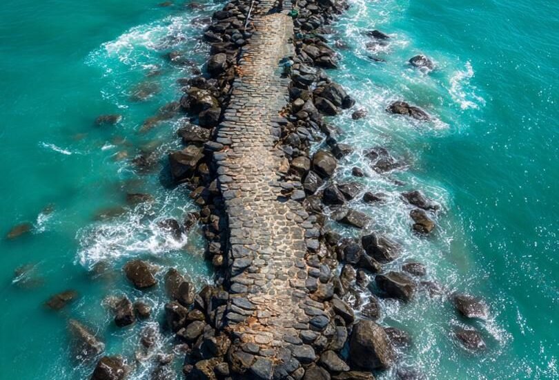
The Layering Paradox
Marine borings conducted by institutions like the National Institute of Ocean Technology (NIOT) revealed that the upper layer of Ram Setu consists of boulders, coarse calcareous sandstone, and coral conglomerates. Surprisingly, these heavy boulders rest on top of a layer of loose marine sand. Under normal oceanic sedimentation, heavier materials sink beneath loose sand over time, leading some geologists to hypothesize that these stones were systematically transported and piled onto the pre-existing sandbanks.
The 10:1 Ratio Harmony
Advanced 3D undersea mapping by the Indian Space Research Organisation (ISRO) using green-laser satellite tracking showcases the ridge rising roughly 8 meters from the ocean floor as a straight, continuous wall. Proponents of the ancient engineering theory frequently highlight that the bridge’s length-to-width ratio closely mirrors the precise $10:1$ proportions dictated in Valmiki’s Yuddha Kanda.
The Sea-Level Timeline
Radiocarbon dating of the coral formations on the bridge places their growth between 3,500 and 7,000 years ago. Geologically, during the Last Glacial Period (when global sea levels were 120 meters lower), India and Sri Lanka shared a completely dry land connection. As the ice caps melted, this limestone ridge remained just below or at the surface, remaining entirely walkable on foot until a catastrophic historic cyclone breached the causeway in 1480 CE.
The Civilizational Connect: India and Lanka
Ram Setu stands as the oldest physical evidence of a shared trans-oceanic ecosystem between India and Sri Lanka. For millennia, this underwater wall has regulated the distinct climates of the two bodies of water it separates: the turbulent Gulf of Mannar and the calm Palk Strait.
 [ Indian Mainland: Rameswaram ]
               │
               ▼
   [ RAM SETU / ADAM'S BRIDGE ]  ◄─── (29 km Submerged Limestone Wall)
               ▲
               │
 [ Sri Lankan Mainland: Mannar ]
Historically, the bridge was never seen as a divider, but as a gateway. Ancient Tamil dynasties, including the Cholas, and the Aryacakravarti kings of Jaffna, continuously documented and protected the “Setu,” adopting the emblem of the bridge on their coinage and copper plate inscriptions as a symbol of their role as guardians of the sacred corridor. It established a shared maritime lifestyle where fishermen, traders, and ascetics crossed seamlessly, binding the destiny of both landmasses.